Saturday, November 1, 2014

Another Beginning, South From Canada to Tierra del Fuego; Nanaimo B.C. to San Cristobal de Las Casas, Chiapas, Mexico.

 Left Nanaimo B.C.Sept. 30th, catching the American ferry out of Victoria for Port Angeles Washington. My intent is to drive relatively quickly to Panama, stopping briefly in New Mexico and in southern Mexico.
The odometer reading, 30,669 kms.
Bike loaded up, including spare tires.

On the ferry in Victoria, off to Port Angeles.
Leaving by the" Empress Hotel" in Victoria's inner harbour
Drove down U.S. interstate 5 to Eugene Oregon, then cut inland to Klamath Falls, Carson City Nevada and then to Death Valley in eastern California. Above, entrance to Death Valley National Monument.
Death Valley in the distance.
Several thousand feet lower, driving below sea level. It was hot, can't imagine going through here in the heart of the summer!
Went on through Las Vegas and Phoenix Arizona into New Mexico. The above photo was taken east of Phoenix near Silver City N. M., the Gila National forest in the distant mountains.
Old western saloon in the hamlet of Pinos Altos, outside of Silver City.
Near Lake Roberts out for a ride with Gayla, a longtime traveling friend since the late 1970's

Gayla's cabin, tucked into the border area of the Gila National Forest. Wildlife abounds, cougar, bear and deer
The cabin, built by hand.
I was put to work for my keep.
Tombstone Arizona, home of Wyatt Earp and the OK Corral. The locals put on a little show.

At a rest stop, east of Tucson Arizona.
 A birthday get together in Tucson, Gayla's siblings, Connie and Becky.
 At the Mexican border, Nogales, south of Tuscon. The border fence snakes over the hills.
 The toll road, heading south towards Guaymas. I decided to take the toll roads all the way south in Mexico, You can make good time and they are in pretty good shape.The last time I was in Mexico, the toll for motorcycles was the same as cars. This time it was half the price of cars. A pleasant surprise and much more affordable!
At a rest stop just north of Mazatlan, the Pacific in the distance.
 South of Mazatlan.
 Jesus and Raul, two friendly truckers at a rest stop.
The road north of Tepic, a city a couple of hours north east of Puerto Vallarta
Tepic toll booth. 

 Near Tepic I swung inland to skirt the megopolis of Mexico City around the north and the east, heading for Puebla, south of the capital. The area is much higher, with a more temperate climate. Quite pretty!
 Near Puebla, lots of volcanic peaks, some active.
South of Puebla at a rest stop coffee shop. I met a Russian guy from Moscow making his way around Mexico catching rides with truckers.
Accommodation in Oaxaca, bike kept in inner courtyard.Nice climate at a higher elevation.

 Leaving Oaxaca and elevation towards Salina Cruz on the Pacific coast
 Twisty road in good condition.
 Taking a break. It was getting warmer.
Stopped in Salina Cruz to ask directions. Family wanted a photo with boy on the bike.
Huge windmill farm south of Salina Cruz, hundreds of them, the most I've ever seen in one place. The area is called the "Ismo" in spanish..Isthmus. The land narrows here between the Caribbean  and the Pacific and their are steady strong winds. It was difficult to maintain much speed on the bike.

 Church in San Cristobal de Las Casas. I'm again at elevation. Bright sunny days and spring like nights.
Indigenous ladies, San Cristobal. This state, Chiapas, and the state of Oaxaca to the north have a huge population of Indigenous people.
They, and their young,still wear colourful clothing, and maintain their culture. I don't see much difference from when I was first here 30 odd years ago.

 Off the main square, San Cristobal.
 What's that Gringo doing??
 Lady vendor'
 Guns guns. Lots of guns around.

 Main square and band shell, San Cristobal.
 Young vendors.
 Street scene, San Cristobal.
 Street, San Cristobal de Las Casas.
Manuel, owner of the Posada where I stayed, ready to take off!

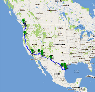
The route so far. Next, Central America. :-]

Friday, June 22, 2012

The U.S. West, Southwest, and north to Canada.

On the causeway to South Padre Island on the Texas coast, 20 miles from Brownsville and the Mexican border.
South Padre was quite nice, for the most part undeveloped.
 Not too touristy and low season prices.
 Along the Mexican border in the valley of the Rio Grande overlooking the city of Laredo. This area along the border is interesting, almost like another country, a blend of Hispanic and American cultures. English is spoken at the counters, but spanish behind.
Bridge over the Pecos River, on its way to the Rio Grande.
Into West Texas along the border west of Del Rio. It has more the feeling of entering the real west, on the way to El Paso.
Gas Stop at Lordsburg, New Mexico and an older station wagon and attached camper.
Visited family in Phoenix, Arizona. My cousin Pauline, husband Mickey and son Casey. Great to see them!
Northwest of Phoenix, a reservoir in "Apache" country.
Tortilla Flats, a small western town northwest of Phoenix.
Sunset in retirement heaven at Apache Junction, 20 minutes east of Phoenix. Friends of mine own a unit  and spend their winters here. Pretty, safe, and dirt cheap.
 Shuffleboard courts.
 At play.,
 John and Eunice, friends from Cassidy, B.C., in front of their winter home.
 On the highway north to Jerome, a small former mining town up in the mountains 2 hours north of Phoenix
Jerome  founded in the late 19th century was a rich source of copper, gold and silver.
Today it is known as an art centre, home to more than 30 galleries. Above the view over the town and of the valley below. The elevation is just over 5000 feet.
On the highway north of Jerome to catch a bit of the famous "Route 66" west. Early March and still a little snow among the trees.
On "Route 66" near Seligman, Arizona. It was early in the season and as a result I had the road pretty well to myself. Lots of neat little American style diners and funky motels.
Classic motel on "66" owned by an interesting Norwegian lady all of 120 lbs. or so, and proud owner of a big white Harley. Notice dust storms in the distance.
Woke up to a dusting of snow the next morning, but soon hit lower elevation and warmer temperatures a couple of hours to the west
Beautiful desert country and a good uncrowded highway.
Sagebrush and cactus.
The Mojave Desert in the distance.
The town of Oatman in western Arizona, a old mining town, now a tourist centre, my last stop on the old "Route 66" before catching the interstate system in California.
Down into the Mojave Desert in southeastern California.
The Mojave
Farmland near the city of Mojave, South eastern California.
Mystic Mount Shasta, northern California.
On the Interstate going through Oregon, one of my favourite American states.
In Eugene, Oregon visiting with Gayla Jean, a long time travelling friend of over 30 years and four continents. Simon, Monica, Casey and Cain, she is now officially part of the trip, having ridden part way of it on the back seat of my bike!
 Gayla and her partner Steve had just sold their sail boat in Thailand and are on their way to Europe to buy a canal boat where they plan to spend the next several years.
After a few days in Eugene I made for the Canadian border. Arrived on March 12th, a rainy blustery day
Through the border and into "Beautiful British Columbia".
Back in Nanaimo with two "heroes" of mine, Denny and Audrey, motorcyclists of a "certain age" and still going strong!!
A True biker babe!
Back where it all started on the concrete pad in front of the garage at my old buddy Frank Bajich's place, where we put the motorcycle into a box and loaded it up for shipment to Tokyo 23 months before. With this last stop the trip and the circumnavigation comes to an end. Just short of 50,000 kms. travelled, 21 countries visited and 9.5 months on the motorcycle over 2 summers and one spring. What a ride!!
3475 miles A-Driscoll, Texas, B-South Padre Island, C-Laredo, D-El Paso, E-Phoenix, Apache Junction, F-Jerome, G-Oatman, H-Mojave, I-Eugene and J-Nanaimo, B.C., Canada.
The total milage on the North American part of the trip--9000 kilometres.