Across the border into Chile, north of Arica, on #5 highway, heading south. Santiago-2091 kms.
Atacama Desert, one of the driest places on earth. The Pan American Highway was in great shape!
A beautiful view on coastal road #1, south of Iquique
San Pedro de Atacama, an oasis town close to the Bolivian and Argentine frontiers, 700 kms. south of the Peruvian border.
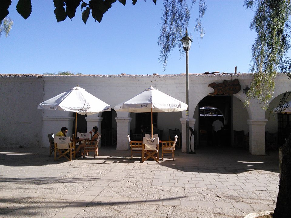
Restaurant in the town square. San Pedro used to be a cattle drive way station on the way to Argentina, but has become something of a tourist spot.
A street off the main square, San Pedro de Atacama.
Road above San Pedro de Atacama. A high desert highway, little traffic.
A lonely wild Alpaca in the heights above San Pedro overlooking the salt plains and salt lakes below.
Massive ore trucks from one of the thousands of open pit mines in northern Chile. Copper is the high octane fuel to Chile's economy.
Gas stop back on the Pan American highway heading south. Lots of heavy mining equipment around.
Fellow travellers, Garry and Bonnie Dymond out of Mexico City, on their way back north after many months of travel through South America. Hope to see them in 2016 on their way to Alaska.
View from my lunch spot at the village of Los Hornos, north of La Serena.
Lunch at the "Stop Here" Restaurant.
Clientele
Bread, congrio (eel), and potato salad...delicioso!!
I spent Christmas in the Elqui Valley, a grape growing area famous for Pisco, avocados, clear night skies and world class observatories.
Small villages, green vegetation where there is water, and the stark desert beyond.
With Martin Delmonte, a french rider.
Further up the valley the roads turned to gravel.
On the Pan American Highway again, north of Santiago. Starting to see more greenery as we get closer to the Capital.
The view from the roof patio of our accommodation in Santiago, "Hostal Casa Matte", situated on a leafy street in the centre of the city. Nowhere in Chile are you without a potential mountain vista.
With Andy and Caroline Pascoe a couple of friends from Nanaimo, New Year's Eve.
Our accommodation, Hostal Casa Matte. Strictly a motorcycle friendly hostel, highly recommended!!
Typical street scene, central Santigo, in front of the Casa Matte.
Central Santiago
It is a city of many parks.
Fran and Cristian," los duenos" of the Casa Matte. Very friendly and most helpful, a home away from home!! If you're motorcycling through Santiago, stay at the "Hostal Casa Matte!!"
Bob Beadle, from Santa Barbara originally but now having lived in Bahia, Brazil for many years. He proved to be a welcome traveling companion off and on from here to Tierra del Fuego.
Bob and the kid, south of Santiago.
Villarica Volcano near Pucon, 790 kms. south of Santiago, north east of Puerto Montt
In the mountains east of Pucon Chile, through Monkey tree forest on the way to the Argentine border.
Chilean side, border crossing into Argentina.
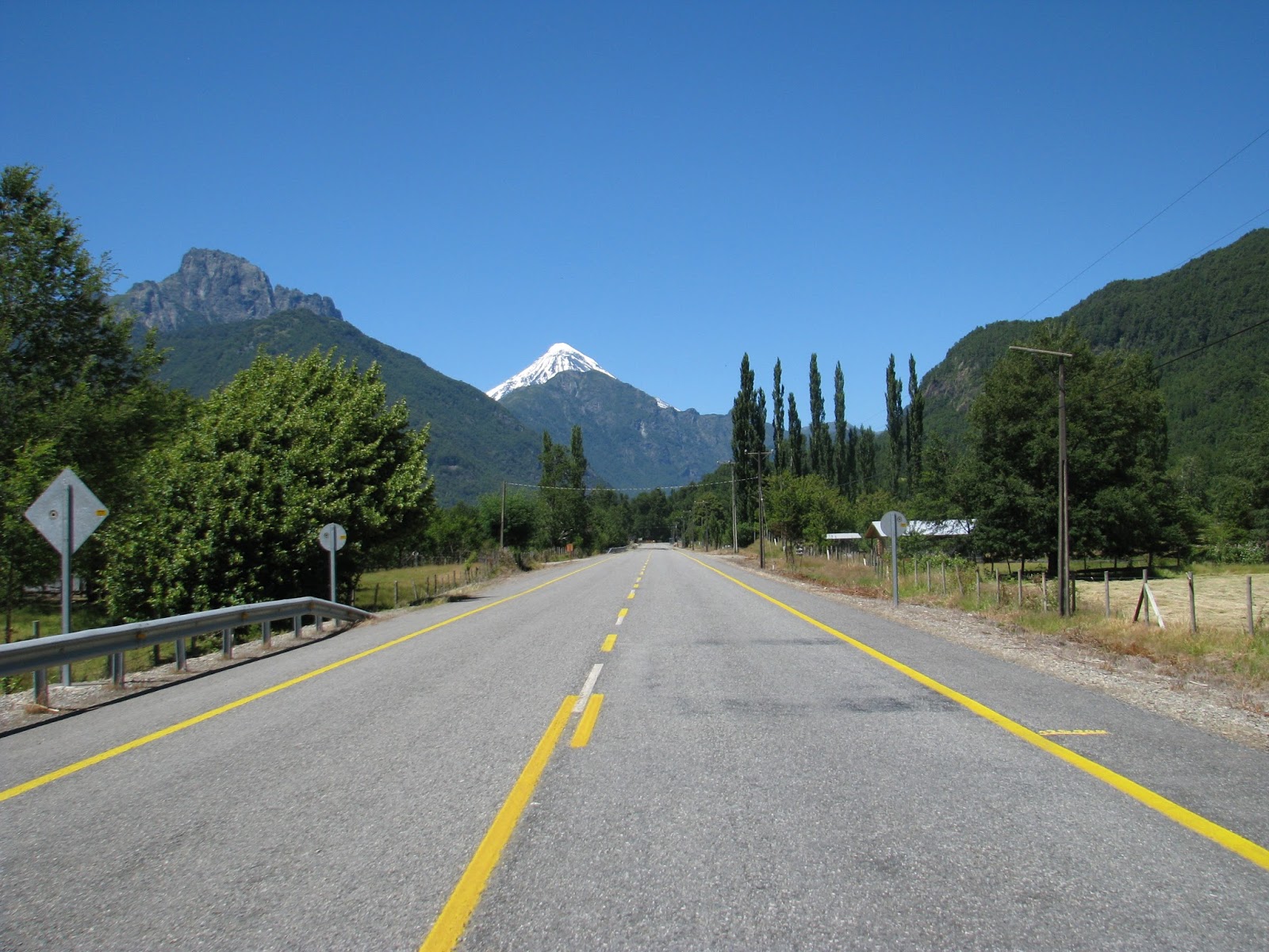
Lanin Volcano on the Chilean-Argentinian border.
Argentine border post, "Paso Mamuil Malal, east of Pucon, Chile.
Into Argentina, route 60 east to connect up with the famous "Ruta 40", which runs north south along the eastern edge of the Andes. Now entering into North western Patagonia.
On "Ruta 40", Lago Lacar and the tourist town of San Martin de los Andes on the shore.
Lake Lacar outside of San Martin on Route 40 going south. An area of great beauty, lakes rivers and mountains.The Argentinian Lake District.
Good roads, Ruta 40, south.
Entering San Carlos de Bariloche, a long time tourist destination in the Argentine lake district.
The Welsh founded town of Trevelin, in the mountains off of Route 40, on the way to cross back into Chile and the Chilean "Carretera Austral".
South of Trevelin and the gravel road to Chile in the distance.
Back in Chile.
The first little town of Futaleufu, Chile.
On through isolated farms to the Carretera Austral, southern Chile. Not heavily travelled.
Beautiful rivers, good trout fishing, a lot like parts of B.C., but with a Latin flavour.
Place to stay for the night, La Junta, on the Carretera Austral.
Misty town square in the morning, La Junta.
There was much more paved road on the Carretera than I expected, and it is proceeding at a rapid pace.
Construction and back onto the dirt.
Misty mountains, rain, and few people.
Coming into the head of a fiord.
Salmon farming. It's a major industry in Chile.
Good gravel road, just take it easy!
Not so good gravel road, soft, wet, and freshly graded.
Pretty!
Back onto the pavement and taking a break.
The town of Coyhaique, a regional capital and ranch town
Main street, Coyhaique.
Looking the other way.
Chileans are very proud of their Hot Dogs, which they call "Completos". This writing on the mirror at a fast food place describes what the hot dog is called in various countries. It says that in Gringolandia, (ie. where the Gringos live), it's called a "hotdog", so I asked for a hotdog instead of a completo. Got a few laughs.
Leaving Coyhaique to catch the ferry across Lago Buenos Aires to the village of Chile Chico, and the Argentinian village of Los Antiguos across the border.
The ferry. It was very windy!
Off and running.
Gassing up the next morning in the village of Perito Moreno in Argentina. Cold and windy out in the Pampas, had to be dressed!
Into the Pampas and "the wind". A real concern when driving in "open" Patagonia. It can be very strong!! A herd of Guanacos at the side of the road.
They are a Llama like animal, and there are thousands of them in Patagonia.
Like the prairies at home, but with wind!
Locals wearing the Gaucho style Beret of Patagonia.
Travellers in Argentina have the ever present thermos of hot water for the national tea drink, Matte
A gravel (ripio) stretch of Ruta 40, north of the town of El Calafate.
Taking a break from the wind. I spent most of the day driving on an angle. Very tiring!
Meeting up with Bob Beadle again in El Calafate, and an English rider, Peter Domhill, who had been on the road from Alaska for a couple of years.
On the way out to the Perito Moreno Glacier a half hour by road out of El Calafate on Lago Argentina
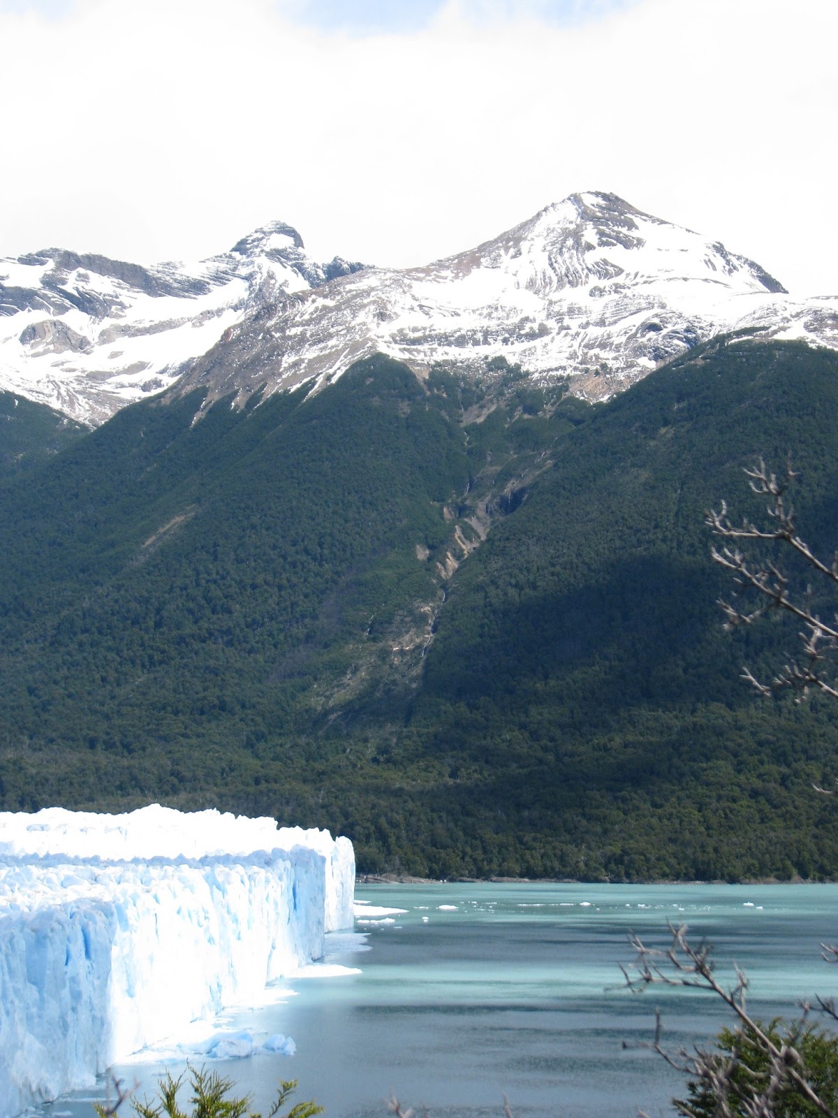
The blue hued Perito Moreno Glacier in the Parque Nacional de Los Glaciares.
It is advancing about 2 meters per day, cracking sounds like loud gunshots fill the air.
The glacier measures 35 kms long, 5 kms wide and 60 meters high. It is constantly calving, dropping chunks off its face.
A Panorama.
On the road back towards El Calafate.
Stopping for lunch back in town.
Peter and Bob at breakfast before leaving for Punta Arenas, Chile, a days drive south.
At a gas stop south of El Calafate, with a mob of Brazilian riders. The run from Brazil down to Tierra del Fuego is very popular with Brazilian motorcyclists.
A curious little Argentine traveller at the pumps.
Bob and I ready to boogie.
Entering Chilean Patagonia, north of Punta Arenas.
Windy and cool, stopping for a coffee.
Punta Arenas, the main city, Chilean Patagonia, Pop.-130,000
Taking a early morning ferry from Punta Arenas to Porvenir on the Chilean section of the Island of Tierra del Fuego.
Leaving Punta Arenas under cloudy skies.
First view of the Island of Tierra del Fuego.
Some gravel road to traverse across the Island.
Bob and Peter enjoying the mud.
Back into the dry, a dusty section.
At last, the entrance to Ushuaia, our ultimate goal, the southernmost town in Argentina!
23,207 kms travelled from Nanaimo B.C. Canada, to Ushuaia, Argentinian Tierra del Fuego.Left September 30, 2014, arrived January 16, 2015. Three and one half months travel time.
The Falkland Islands still very much on Argentinian minds. The sign says, "The Malvinas are Argentina's."
The view back from the town entrance. The Andes curve out and around to the east at the southernmost reaches of the continent.
The end of Ruta 3, the direct road north, 3000 kms. to Buenos Aires.
The Hostal de Mochileros, our accommodation in Ushuaia. Rooms were tight, it was very busy. Great place to stay, and Alejandro an excellent host. Highly recommended!
Street scene looking towards the harbour from the Hostel.
Main street, Ushuaia. It's high season and it was full of tourists from all over the world.
A great mountain backdrop, lots of snow in the winter.
Bob, Peter and myself," End of the World", the harbour, Ushuaia
The harbour, Chile in the distant mountains.
Street view, Ushuaia.
The English still not too popular in Argentina. This sign at the main port entrance says, "English Pirate Ships Prohibited from Docking".
Myself and the Beemer at the end of the line.
6500 kms., from the northern border of Chile to Ushuaia, Tierra del Fuego.